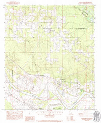
1983 Map of Fairview Alpha
USGS Topo · Published 1984About this map
The Red River and its intricate drainage network dominate this section of the Louisiana landscape, where the Kansas City Southern and Missouri Pacific railroads follow the river's winding course. This area at the border of Red River Parish and Natchitoches Parish is dotted with small rural communities and local landmarks like Grappes Bluff. The settlement at Fairview Alpha serves as a local hub, surrounded by a dense distribution of country churches including Fairview Ch, Zion Ch, and Calvary Ch. The hydrology of the floodplain is particularly well-documented, showing the relationship between the active Red River, the Old River loop, and various backwaters such as Lake Poule d'eau and Blue Lake. Genealogists will find significant value in the mapped locations of Hawes Cem and Nativity Cem, which anchor the history of these river-side communities.
Find a feature on this map
30 named features on this map. Tap any name to fly to it.
Don’t see what you’re looking for? This feature index may not catch every label — zoom into the map to look around manually.
Map Details
Editions of this 1983 Fairview Alpha Map
This is the sole edition of this map. No revisions or reprints were ever made.
Other maps of this area

1937 · Campti NE
USGS Topo · 1:31,680

1937 · Campti SE
USGS Topo · 1:31,680

1937 · Campti NW
USGS Topo · 1:31,680

1937 · Campti SW
USGS Topo · 1:31,680

1938 · Allen
USGS Topo · 1:31,680

1938 · Lake End
USGS Topo · 1:31,680

1944 · Campti
USGS Topo · 1:62,500

1947 · Ashland
USGS Topo · 1:62,500

1947 · Hanna
USGS Topo · 1:62,500

1948 · Coushatta
USGS Topo · 1:62,500