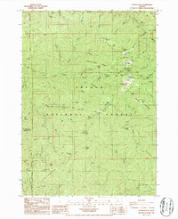
1986 Map of Fairview Peak
USGS Topo · Published 1987About this map
Bohemia City and the historic mining district of the Calapooya Mountains are the focal points of this 1986 survey along the Lane and Douglas county line. The landscape is defined by the high crest of the Umpqua Divide and Calapooya Divide, where several significant mining operations are clustered. Notable sites include the Musick Mine, Vesuvius Mine, and the Wildhog Mine near Bohemia Saddle. The prominence of Fairview Peak is marked by its Lookout Tower, overseeing a network of steep drainages like Sharps Creek and Champion Creek. This record documents the transition of the area from an active extractive region to a managed forest, preserving locations like the Glenwood (Site) and the Musick FS Sta within the Willamette and Umpqua National Forests.
Find a feature on this map
79 named features on this map. Tap any name to fly to it.
Don’t see what you’re looking for? This feature index may not catch every label — zoom into the map to look around manually.
Map Details
Editions of this 1986 Fairview Peak Map
This is the sole edition of this map. No revisions or reprints were ever made.
Other maps of this area

1935 · Lowell
USGS Topo · 1:96,000

1942 · Lowell
USGS Topo · 1:125,000

1955 · Mace Mtn
USGS Topo · 1:62,500

1955 · Illahee Rock
USGS Topo · 1:62,500

1955 · Fairview Peak
USGS Topo · 1:62,500

1955 · Culp Creek
USGS Topo · 1:62,500

1958 · Roseburg
USGS Topo · 1:250,000

1959 · Roseburg
USGS Topo · 1:250,000

1978 · Diamond Lake
USGS Topo · 1:100,000

1983 · Oakridge
USGS Topo · 1:100,000