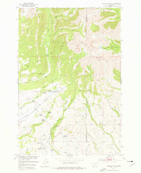
1951 Map of Fairview Peak
USGS Topo · Published 1976About this map
The high elevations of the Crazy Mountains dominate this 1951 field-checked landscape, where the transition from forest to rocky peaks is marked by a legacy of early ranching and resource extraction. Within the Gallatin National Forest, numerous family names are preserved on the land, though by mid-century, many of these sites were already listed as abandoned. These include the Cole Homestead (Aban'd), Gilbert Homestead (Aban'd), and Payne Homestead (Aban'd), showing a pattern of high-altitude settlement that had largely receded by the time of the survey.
Find a feature on this map
42 named features on this map. Tap any name to fly to it.
Don’t see what you’re looking for? This feature index may not catch every label — zoom into the map to look around manually.
Map Details
Editions of this 1951 Fairview Peak Map
4 editions found
Other maps of this area

1886 · Little Belt Mts.
USGS Topo · 1:250,000

1891 · Livingston
USGS Topo · 1:250,000

1893 · Livingston
USGS Topo · 1:250,000

1894 · Little Belt Mts.
USGS Topo · 1:250,000

1897 · Little Belt Mts.
USGS Topo · 1:250,000

1898 · Little Belt Mts.
USGS Topo · 1:250,000

1902 · Little Belt Mts.
USGS Topo · 1:250,000

1947 · Bozeman
USGS Topo · 1:250,000

1948 · Bozeman
USGS Topo · 1:250,000

1948 · White Sulphur Springs
USGS Topo · 1:250,000