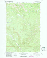
1970 Map of Fairview Ridge
USGS Topo · Published 1987About this map
Yakima Indian Reservation lands dominate this mid-century topographic study, which defines the transition from high ridgelines to the deep river valleys of south-central Washington. The Klickitat River snakes through the southwestern corner of the sheet, providing a primary drainage point for tributaries like the Diamond Meadow Fork and Coyote Creek. Evidence of early 20th-century land management is clearly marked by the Old Indian Reservation Boundary (Campbell Line 1906-07), which traces a historical property line across the high country. Small-scale outposts like Kesslers Ranch and Klickitat Camp offer rare markers of human habitation in a landscape otherwise defined by prominent landmarks such as Fairview Ridge, Sheep Point, and the unusual depression of Cultus Hole. The network of seasonal springs and the Old Maid Piscoe Road suggest a landscape used primarily for ranching and resource management.
Find a feature on this map
28 named features on this map. Tap any name to fly to it.
Don’t see what you’re looking for? This feature index may not catch every label — zoom into the map to look around manually.
Map Details
Editions of this 1970 Fairview Ridge Map
2 editions found
Other maps of this area

1902 · Mount Aix
USGS Topo · 1:125,000

1904 · Mt Aix
USGS Topo · 1:125,000

1904 · Mount Adams
USGS Topo · 1:125,000

1907 · Mount Adams
USGS Topo · 1:125,000

1950 · Yakima
USGS Topo · 1:250,000

1958 · Yakima
USGS Topo · 1:250,000

1961 · Yakima
USGS Topo · 1:250,000

1962 · White Pass
USGS Topo · 1:62,500

1967 · Darland Mtn
USGS Topo · 1:24,000
1967 · Foundation Ridge
USGS Topo · 1:24,000