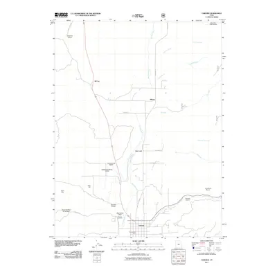
2011 Map of Fairview
USGS Topo · Published 2011About this map
Fairview anchors the southern portion of this landscape, situated where the valley floor begins its ascent into the highlands of the Wasatch Range. The town's grid is clearly defined, featuring the Fairview Post Office and the Fairview Cemetery near the junction of Cottonwood Creek and the San Pitch River. To the north, the small settlements of Milburn, Oak Creek, and Hill Top trace a path through the valley, connected by local routes like Milburn Rd and Hill Top Rd.
Find a feature on this map
36 named features on this map. Tap any name to fly to it.
Don’t see what you’re looking for? This feature index may not catch every label — zoom into the map to look around manually.
Map Details
Editions of this 2011 Fairview Map
This is the sole edition of this map. No revisions or reprints were ever made.
Other maps of this area

1885 · Manti
USGS Topo · 1:250,000

1895 · Manti
USGS Topo · 1:250,000

1951 · Moroni
USGS Topo · 1:62,500

1952 · Santaquin Peak
USGS Topo · 1:62,500

1956 · Price
USGS Topo · 1:250,000

1960 · Price
USGS Topo · 1:250,000

1962 · Price
USGS Topo · 1:250,000

1965 · Huntington Reservoir
USGS Topo · 1:24,000

1965 · Fairview Lakes
USGS Topo · 1:24,000
1967 · Indianola
USGS Topo · 1:24,000