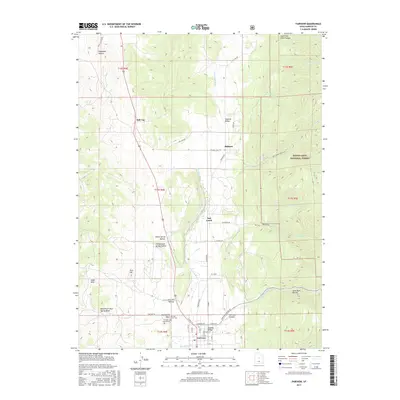
2017 Map of Fairview
USGS Topo · Published 2017About this map
Fairview anchors the southern edge of this map, situated in the fertile Sanpete Valley where Cottonwood Cr meets the north-flowing San Pitch River. This survey illustrates the transition from the valley floor's grid-based agricultural settlements to the rising elevations of the Manti-La Sal National Forest to the east. Local history and genealogy interests are well-served by the inclusion of both the Fairview Upper Cem and Fairview Lower Cem, located just west of the town center near Mud Spring Wash.
Find a feature on this map
59 named features on this map. Tap any name to fly to it.
Don’t see what you’re looking for? This feature index may not catch every label — zoom into the map to look around manually.
Map Details
Editions of this 2017 Fairview Map
This is the sole edition of this map. No revisions or reprints were ever made.
Other maps of this area

1885 · Manti
USGS Topo · 1:250,000

1895 · Manti
USGS Topo · 1:250,000

1951 · Moroni
USGS Topo · 1:62,500

1952 · Santaquin Peak
USGS Topo · 1:62,500

1956 · Price
USGS Topo · 1:250,000

1960 · Price
USGS Topo · 1:250,000

1962 · Price
USGS Topo · 1:250,000

1965 · Huntington Reservoir
USGS Topo · 1:24,000

1965 · Fairview Lakes
USGS Topo · 1:24,000
1967 · Indianola
USGS Topo · 1:24,000