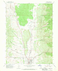
1967 Map of Fairview
USGS Topo · Published 1969About this map
Sanpete Valley serves as the central corridor for this 1960s study, where the Denver and Rio Grande Western railroad tracks parallel the San Pitch River. The settlement of Fairview occupies the southern valley floor, anchored by its Athletic Field and the nearby Fairview Cemetery. To the east, the terrain rises sharply into the Manti-La Sal National Forest, where deep cuts like Cottonwood Canyon and Lone Rock Ravine define the mountain front. The landscape reflects a mix of agricultural infrastructure and early industrial utility, evidenced by a Powerplant and a Gaging Station along the waterways. Smaller outposts like Milburn, Oak Creek, and Hill Top mark the transitions between the valley floor and the surrounding Cedar Hills, connected by a network of unimproved roads and a Jeep Trail.
Find a feature on this map
33 named features on this map. Tap any name to fly to it.
Don’t see what you’re looking for? This feature index may not catch every label — zoom into the map to look around manually.
Map Details
Editions of this 1967 Fairview Map
This is the sole edition of this map. No revisions or reprints were ever made.
Other maps of this area

1885 · Manti
USGS Topo · 1:250,000

1895 · Manti
USGS Topo · 1:250,000

1951 · Moroni
USGS Topo · 1:62,500

1952 · Santaquin Peak
USGS Topo · 1:62,500

1956 · Price
USGS Topo · 1:250,000

1960 · Price
USGS Topo · 1:250,000

1962 · Price
USGS Topo · 1:250,000

1965 · Huntington Reservoir
USGS Topo · 1:24,000

1965 · Fairview Lakes
USGS Topo · 1:24,000
1967 · Indianola
USGS Topo · 1:24,000