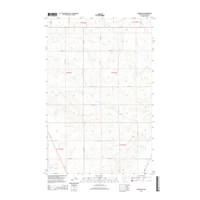
2014 Map of Fairview SW
USGS Topo · Published 2014About this map
First Hay Creek and its northern branch, the N Fork First Hay Creek, define the central drainage of this Richland County landscape. The terrain is a network of coulees and ridges typical of the Missouri River breaks, though the river itself remains beyond the map's eastern border. The southeastern corner reveals a transition into an engineered agricultural landscape where the Main Canal and Lateral G distribute water to the flatter plains. Transportation is dictated by the section-line grid, with primary access provided by MT-201 in the north and MT-200 in the southeast. While largely an area of open rangeland and dryland farming, the presence of a Spring near the canal system suggests the localized importance of water sources in this semi-arid region.
Find a feature on this map
30 named features on this map. Tap any name to fly to it.
Don’t see what you’re looking for? This feature index may not catch every label — zoom into the map to look around manually.
Map Details
Editions of this 2014 Fairview SW Map
This is the sole edition of this map. No revisions or reprints were ever made.
Other maps of this area

1909 · Glendive
USGS Topo · 1:250,000

1954 · Glendive
USGS Topo · 1:250,000

1957 · Glendive
USGS Topo · 1:250,000

1958 · Glendive
USGS Topo · 1:250,000

1966 · Crane NE
USGS Topo · 1:24,000

1966 · Sidney NE
USGS Topo · 1:24,000

1966 · Sidney
USGS Topo · 1:24,000
1968 · Dore
USGS Topo · 1:24,000

1972 · Brorson
USGS Topo · 1:24,000
1972 · Fairview
USGS Topo · 1:24,000