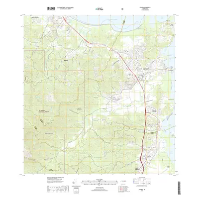
2018 Map of Fajardo
USGS Topo · Published 2018About this map
Fajardo serves as the primary urban center on this coastal survey, where the town's grid meets the complex inlets of Puerto Chico and the Bahia de Fajardo. To the west, the landscape rises sharply into the protected highlands of El Yunque National Forest, a terrain of steep ridges like Cuchilla Naranjo and numerous headwaters including Quebrada Juan Diego and Quebrada Sonadora. The northeastern tip of the island is defined by the prominent Cabo San Juan and the nearby fishing village of Las Croabas, while the southern portion of the map transitions into the municipal area of Ceiba. This region exhibits a diverse coastal geography, from the sheltered Bahia Demajagua to the modern aviation facilities at Jose Aponte de la Torre Airport, illustrating the balance between dense tropical forest, maritime infrastructure, and expanding residential settlements like Luis M. Cintron and Aguas Claras.
Find a feature on this map
49 named features on this map. Tap any name to fly to it.
Don’t see what you’re looking for? This feature index may not catch every label — zoom into the map to look around manually.
Map Details
Editions of this 2018 Fajardo Map
This is the sole edition of this map. No revisions or reprints were ever made.
Other maps of this area

1941 · Rio Grande
USGS Topo · 1:30,000

1945 · Cayo Icacos
USGS Topo · 1:30,000

1945 · El Yunque
USGS Topo · 1:30,000

1946 · El Yunque
USGS Topo · 1:30,000

1946 · Humacao
USGS Topo · 1:30,000

1946 · Punta Puerca
USGS Topo · 1:30,000

1946 · Naguabo
USGS Topo · 1:30,000

1946 · Fajardo
USGS Topo · 1:30,000

1947 · El Yunque NE
USGS Topo · 1:10,000

1947 · Rio Grande
USGS Topo · 1:30,000