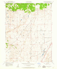
1948 Map of Falcon NW
USGS Topo · Published 1960About this map
Black Forest dominates the northern landscape of this El Paso County area, where the wooded highland gives way to a network of drainage basins and ranching operations. The Chicago Rock Island and Pacific railroad cuts through the southeastern corner, serving as a primary transit artery alongside local thoroughfares like Burgess Road and Vollmer Road. Numerous windmills are marked across the terrain, indicating the reliance on groundwater for the livestock at Wolf Ranch, Hyatt Ranch, and Banning Lewis Ranch. Waterways such as Sand Creek, Cottonwood Creek, and Jimmy Camp Creek define the topography, while an Underground Pipeline reveals mid-century infrastructure developments in this prairie environment. This document reflects a transitional period of land use in the late 1940s before the significant suburban expansion of nearby Colorado Springs.
Find a feature on this map
14 named features on this map. Tap any name to fly to it.
Don’t see what you’re looking for? This feature index may not catch every label — zoom into the map to look around manually.
Map Details
Editions of this 1948 Falcon NW Map
This is the sole edition of this map. No revisions or reprints were ever made.
Other maps of this area

1893 · Colorado Springs
USGS Topo · 1:125,000

1894 · Castle Rock
USGS Topo · 1:125,000

1909 · Colorado Springs
USGS Topo · 1:125,000

1913 · Castle Rock
USGS Topo · 1:125,000

1940 · Elbert
USGS Topo · 1:62,500

1942 · Colorado Springs
USGS Topo · 1:125,000

1944 · Elbert
USGS Topo · 1:62,500

1948 · Falcon
USGS Topo · 1:24,000

1948 · Colorado Springs
USGS Topo · 1:62,500

1948 · Pikeview
USGS Topo · 1:24,000