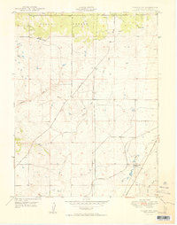
1950 Map of Falcon NW
USGS Topo · Published 1950About this map
Black Forest dominates the northern landscape of this El Paso County area, where the high-altitude terrain transitions into the ranching country of the mid-century. Large landholdings like Wolf Ranch, Hyatt Ranch, and the Banning Lewis Ranch define the settlement pattern, anchored by a series of arterial routes including Vollmer Road and Templeton Gap Road. The presence of scattered windmills and a prominent underground pipeline reflect the practical needs of water management and infrastructure in this semi-arid environment.
Find a feature on this map
14 named features on this map. Tap any name to fly to it.
Don’t see what you’re looking for? This feature index may not catch every label — zoom into the map to look around manually.
Map Details
Editions of this 1950 Falcon NW Map
2 editions found
Other maps of this area

1893 · Colorado Springs
USGS Topo · 1:125,000

1894 · Castle Rock
USGS Topo · 1:125,000

1909 · Colorado Springs
USGS Topo · 1:125,000

1913 · Castle Rock
USGS Topo · 1:125,000

1940 · Elbert
USGS Topo · 1:62,500

1942 · Colorado Springs
USGS Topo · 1:125,000

1944 · Elbert
USGS Topo · 1:62,500

1948 · Falcon
USGS Topo · 1:24,000

1948 · Colorado Springs
USGS Topo · 1:62,500

1948 · Pikeview
USGS Topo · 1:24,000