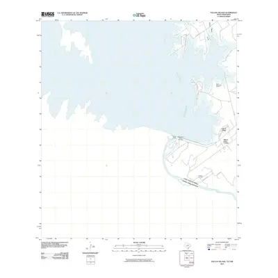
2010 Map of Falcon Village
USGS Topo · Published 2010About this map
The International Falcon Lake Dam and Falcon Dam stand as the central landmarks of this borderland survey, marking the point where the Rio Grande is impounded to form the massive Falcon Reservoir. The geography is defined by the international boundary between the United States and Mexico, with the landscape carved by seasonal waterways like Arroyo Medio and Arroyo Morteros. On the Texas side, the residential community of Falcon Village and the Miguel Garza Colonia sit near the reservoir’s edge, supported by infrastructure including Falcon State Park and the Falcon State Park Airport. Genealogists may find interest in the Chapeno Cemetery, located south of the dam near Swordfish Dr. The map illustrates a modern era of water management and recreation along the border, showing how the reservoir has reshaped the traditional river valley into a structured landscape of parks and settlements.
Find a feature on this map
18 named features on this map. Tap any name to fly to it.
Don’t see what you’re looking for? This feature index may not catch every label — zoom into the map to look around manually.
Map Details
Editions of this 2010 Falcon Village Map
This is the sole edition of this map. No revisions or reprints were ever made.
Other maps of this area

1938 · Falcon
USGS Topo · 1:62,500

1949 · Mc Allen
USGS Topo · 1:250,000

1954 · McAllen
USGS Topo · 1:250,000

1956 · Roma
USGS Topo · 1:62,500

1957 · Mc Allen
USGS Topo · 1:250,000

1962 · McAllen
USGS Topo · 1:250,000

1965 · Salineno
USGS Topo · 1:24,000
1965 · Falcon Village
USGS Topo · 1:24,000

1965 · Lopeno
USGS Topo · 1:24,000
1965 · Beckwith Arm
USGS Topo · 1:24,000