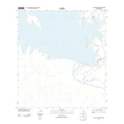
2012 Map of Falcon Village
USGS Topo · Published 2012About this map
Falcon Reservoir dominates the landscape on the international border between Texas and Tamaulipas, Mexico. This 2012 survey illustrates the rugged brushland and drainage systems south of the dam, where the Rio Grande continues its course past Chapeno Cem. The settlement of Falcon Village serves as a residential hub for the area, connected by a network of local roads such as Ranch Road 2098 and Reservoir Rd. To the north, the fingers of the reservoir reach into the terrain at Arroyo Medio, while Falcon State Park occupies a significant portion of the shoreline, offering access to the water via St Park Road 46. The map captures the distinct boundary between the managed parklands and the open arroyos, including Arroyo Morteros, that define this borderland environment.
Find a feature on this map
18 named features on this map. Tap any name to fly to it.
Don’t see what you’re looking for? This feature index may not catch every label — zoom into the map to look around manually.
Map Details
Editions of this 2012 Falcon Village Map
This is the sole edition of this map. No revisions or reprints were ever made.
Other maps of this area

1938 · Falcon
USGS Topo · 1:62,500

1949 · Mc Allen
USGS Topo · 1:250,000

1954 · McAllen
USGS Topo · 1:250,000

1956 · Roma
USGS Topo · 1:62,500

1957 · Mc Allen
USGS Topo · 1:250,000

1962 · McAllen
USGS Topo · 1:250,000

1965 · Salineno
USGS Topo · 1:24,000
1965 · Falcon Village
USGS Topo · 1:24,000

1965 · Lopeno
USGS Topo · 1:24,000
1965 · Beckwith Arm
USGS Topo · 1:24,000