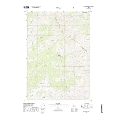
2020 Map of Falconberry Peak
USGS Topo · Published 2020About this map
Falconberry Peak and Grouse Creek Peak dominate this high-elevation landscape within the Challis National Forest. The map documents a complex drainage system defined by the prominent Loon Creek, which is fed by numerous tributaries including Yellow Cat Cr, Horse Cr, and Burn Cr. This survey illustrates the intricate topography of Custer and Lemhi counties, where the land is carved by the Castle Fork and Cliff Cr. Human passage through this steep terrain is limited to routes like the Grouse Creek Rd, which traces the lower elevations near Grouse Cr. The map provides a look at the wilderness character of the region, showing the convergence of various creek systems and the prominence of landmarks such as Loon Creek Point in a region largely defined by its natural watersheds.
Find a feature on this map
33 named features on this map. Tap any name to fly to it.
Don’t see what you’re looking for? This feature index may not catch every label — zoom into the map to look around manually.
Map Details
Editions of this 2020 Falconberry Peak Map
This is the sole edition of this map. No revisions or reprints were ever made.
Other maps of this area

1930 · Casto
USGS Topo · 1:125,000

1957 · Challis
USGS Topo · 1:250,000

1960 · Challis
USGS Topo · 1:250,000

1962 · Norton Ridge
USGS Topo · 1:24,000

1962 · Ramey Hill
USGS Topo · 1:24,000

1963 · Challis
USGS Topo · 1:250,000

1963 · Pinyon Peak
USGS Topo · 1:24,000

1963 · Casto
USGS Topo · 1:24,000

1963 · Rock Creek
USGS Topo · 1:24,000
1963 · Sherman Peak
USGS Topo · 1:24,000