
1963 Map of Rock Creek
USGS Topo · Published 1964About this map
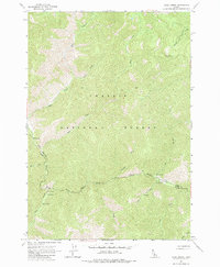
Challis National Forest dominates this mid-century survey of the Idaho backcountry, straddling the high-elevation boundary between Lemhi and Custer Counties. The landscape is defined by its hydrothermal activity and narrow access points, featuring multiple Hot Springs and the Owen Cabin located along the deep drainage of Loon Creek. Human activity is concentrated around river travel and backcountry aviation, notably at the Foster Ranch Landing Strip situated along the winding Warm Spring Creek. While largely unpopulated, the area shows early recreational development with established sites like Rock Creek Campground and South Fork Campground. The network of drainages, including South Fork Camas Creek and Kelly Creek, illustrates the complex watershed of this mountainous region before modern road expansion.
Find a feature on this map
20 named features on this map. Tap any name to fly to it.
Don’t see what you’re looking for? This feature index may not catch every label — zoom into the map to look around manually.
Map Details
Editions of this 1963 Rock Creek Map
2 editions found
Other maps of this area

1930 · Casto
USGS Topo · 1:125,000

1957 · Challis
USGS Topo · 1:250,000

1960 · Challis
USGS Topo · 1:250,000

1962 · Ramey Hill
USGS Topo · 1:24,000

1963 · Challis
USGS Topo · 1:250,000

1963 · Challis Creek Lakes
USGS Topo · 1:24,000

1963 · Meyers Cove
USGS Topo · 1:24,000

1963 · Casto
USGS Topo · 1:24,000
1963 · Sherman Peak
USGS Topo · 1:24,000
1963 · Sleeping Deer Mountain
USGS Topo · 1:24,000