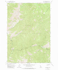
1963 Map of Rock Creek
USGS Topo · Published 1985About this map
Challis National Forest dominates this mountain landscape, which sits at the jurisdictional boundary of Lemhi and Custer Counties. The terrain is defined by a dense network of high-elevation drainages including Rock Creek, Warm Spring Creek, and Loon Creek. Human activity is concentrated around specialized outposts, such as Owen Cabin and the Foster Ranch Landing Strip, indicating the area's importance for aviation access and seasonal habitation in the backcountry. A series of Hot Springs and geothermal markers are mapped along the creek beds, alongside established recreational sites like the Rock Creek Campground and South Fork Campground. The survey provides a clear view of the complex hydrology of the Salmon River mountains before modern wilderness management shifted the focus of these remote ranching and forest service sites.
Find a feature on this map
18 named features on this map. Tap any name to fly to it.
Don’t see what you’re looking for? This feature index may not catch every label — zoom into the map to look around manually.
Map Details
Editions of this 1963 Rock Creek Map
2 editions found
Other maps of this area

1930 · Casto
USGS Topo · 1:125,000

1957 · Challis
USGS Topo · 1:250,000

1960 · Challis
USGS Topo · 1:250,000

1962 · Ramey Hill
USGS Topo · 1:24,000

1963 · Challis
USGS Topo · 1:250,000

1963 · Challis Creek Lakes
USGS Topo · 1:24,000

1963 · Meyers Cove
USGS Topo · 1:24,000

1963 · Casto
USGS Topo · 1:24,000

1963 · Rock Creek
USGS Topo · 1:24,000
1963 · Sherman Peak
USGS Topo · 1:24,000