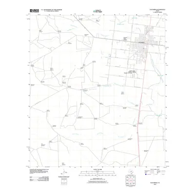
2010 Map of Falfurrias
USGS Topo · Published 2010About this map
Falfurrias serves as the focal point of this South Texas landscape, where the intersection of water access and ranching infrastructure defines the settlement pattern. The town is situated near the confluence of Palo Blanco Creek and Cibolo Creek, surrounded by a dense network of water-drawing points essential for the regional cattle industry. Numerous named landmarks like Esperanza Windmill, Rodeo Windmill, and Soledad Windmill are distributed across the terrain, indicating the historical reliance on groundwater.
Find a feature on this map
69 named features on this map. Tap any name to fly to it.
Don’t see what you’re looking for? This feature index may not catch every label — zoom into the map to look around manually.
Map Details
Editions of this 2010 Falfurrias Map
This is the sole edition of this map. No revisions or reprints were ever made.
Other maps of this area

1921 · Falfurrias
USGS Topo · 1:125,000

1956 · Laredo
USGS Topo · 1:250,000

1963 · Flowella
USGS Topo · 1:24,000

1963 · Falfurrias SE
USGS Topo · 1:24,000

1963 · Premont West
USGS Topo · 1:24,000

1963 · Cage Ranch
USGS Topo · 1:24,000
1963 · Premont East
USGS Topo · 1:24,000

1963 · Falfurrias
USGS Topo · 1:24,000

1968 · Palomas Ranch SE
USGS Topo · 1:24,000

1968 · Palomas Ranch
USGS Topo · 1:24,000