
1963 Map of Falfurrias
USGS Topo · Published 1965About this map
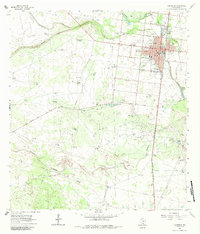
The town of Falfurrias serves as the focal point of this South Texas landscape, where the town's street grid meets the Southern Pacific rail line. The map highlights a developed urban core featuring a Courthouse, Post Office, and educational facilities like the Central Ward Jr High Sch and a High School. Beyond the town center, the landscape is defined by a mix of heavy industry and sprawling ranch lands. The A Gloria Oil Field and Cage Gas Field signal the region's mid-century energy production, while numerous windmills are scattered across the brush country to support remote outposts like La Mota Ranch and Hollywood Camp. Water features such as La Hedionda Lake and the Palo Blanco Creek drainage cut through the terrain, which is also marked by shifting sand dunes to the south, illustrating the arid conditions of Brooks County.
Find a feature on this map
33 named features on this map. Tap any name to fly to it.
Don’t see what you’re looking for? This feature index may not catch every label — zoom into the map to look around manually.
Map Details
Editions of this 1963 Falfurrias Map
2 editions found
Other maps of this area

1921 · Falfurrias
USGS Topo · 1:125,000

1956 · Laredo
USGS Topo · 1:250,000

1963 · Flowella
USGS Topo · 1:24,000

1963 · Falfurrias SE
USGS Topo · 1:24,000

1963 · Premont West
USGS Topo · 1:24,000

1963 · Cage Ranch
USGS Topo · 1:24,000
1963 · Premont East
USGS Topo · 1:24,000

1968 · Palomas Ranch SE
USGS Topo · 1:24,000

1968 · Palomas Ranch
USGS Topo · 1:24,000
1969 · Laguna Del Toro
USGS Topo · 1:24,000