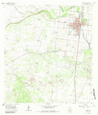
1963 Map of Falfurrias
USGS Topo · Published 1984About this map
Falfurrias serves as the hub of this South Texas landscape, situated at the junction of the Southern Pacific railroad and a network of ranch roads during the early 1960s. The town's grid is well-defined by streets such as Blucher St and St Mary St, supporting local institutions like the Jr High Sch and a Drive-in Theater on the northern outskirts. Beyond the town limits, the terrain transitions into a mosaic of working cattle ranches and energy production, marked by the La Gloria Oil Field and Cage Gas Field.
Find a feature on this map
85 named features on this map. Tap any name to fly to it.
Don’t see what you’re looking for? This feature index may not catch every label — zoom into the map to look around manually.
Map Details
Editions of this 1963 Falfurrias Map
2 editions found
Other maps of this area

1921 · Falfurrias
USGS Topo · 1:125,000

1956 · Laredo
USGS Topo · 1:250,000

1963 · Flowella
USGS Topo · 1:24,000

1963 · Falfurrias SE
USGS Topo · 1:24,000

1963 · Premont West
USGS Topo · 1:24,000

1963 · Cage Ranch
USGS Topo · 1:24,000
1963 · Premont East
USGS Topo · 1:24,000

1963 · Falfurrias
USGS Topo · 1:24,000

1968 · Palomas Ranch SE
USGS Topo · 1:24,000

1968 · Palomas Ranch
USGS Topo · 1:24,000