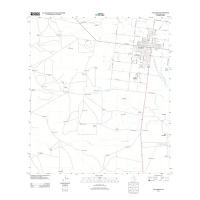
2013 Map of Falfurrias
USGS Topo · Published 2013About this map
Falfurrias serves as the hub of this South Texas landscape, where the town's street grid extends toward the Brooks County Airport and the residential Cantu Addition. The surrounding terrain is defined by a distinct ranching infrastructure, characterized by an extensive network of named windmills and family holdings. Significant watercourses like Palo Blanco Cr and Arroyo Baluarte meander through the countryside, supporting local operations such as the Miller Ranch and La Mota Ranch. For those researching local heritage, the Old Town Cem and the Old Town Windmill provide specific points of interest on the western outskirts of the city. The map also captures smaller peripheral settlements including La India and Alto Colorado, illustrating the transition from the concentrated urban center to the wide-reaching agricultural and ranching tracts typical of Brooks County.
Find a feature on this map
98 named features on this map. Tap any name to fly to it.
Don’t see what you’re looking for? This feature index may not catch every label — zoom into the map to look around manually.
Map Details
Editions of this 2013 Falfurrias Map
This is the sole edition of this map. No revisions or reprints were ever made.
Other maps of this area

1921 · Falfurrias
USGS Topo · 1:125,000

1956 · Laredo
USGS Topo · 1:250,000

1963 · Flowella
USGS Topo · 1:24,000

1963 · Falfurrias SE
USGS Topo · 1:24,000

1963 · Premont West
USGS Topo · 1:24,000

1963 · Cage Ranch
USGS Topo · 1:24,000
1963 · Premont East
USGS Topo · 1:24,000

1963 · Falfurrias
USGS Topo · 1:24,000

1968 · Palomas Ranch SE
USGS Topo · 1:24,000

1968 · Palomas Ranch
USGS Topo · 1:24,000