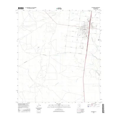
2016 Map of Falfurrias
USGS Topo · Published 2016About this map
Falfurrias serves as the primary hub of this South Texas landscape, where the town's street grid is clearly defined between Palo Blanco Cr and the drainage of Arroyo Baluarte. The map captures a mix of ranching country and aviation infrastructure, anchored by the Brooks County Airport and a network of county roads like Co RD 201 and Co RD 103. Local history is preserved at the Old Town Cem, while the surrounding terrain is marked by intermittent water features including La Hedionda Lake, Burro Lake, and Mesquite Lake. The intricate system of creeks, such as Una de Gato Cr and Laborcitas Cr, illustrates the hydrological pattern of this semi-arid region, showing how settlement and transportation have historically followed these natural drainages and depressions.
Find a feature on this map
67 named features on this map. Tap any name to fly to it.
Don’t see what you’re looking for? This feature index may not catch every label — zoom into the map to look around manually.
Map Details
Editions of this 2016 Falfurrias Map
This is the sole edition of this map. No revisions or reprints were ever made.
Other maps of this area

1921 · Falfurrias
USGS Topo · 1:125,000

1956 · Laredo
USGS Topo · 1:250,000

1963 · Flowella
USGS Topo · 1:24,000

1963 · Falfurrias SE
USGS Topo · 1:24,000

1963 · Premont West
USGS Topo · 1:24,000

1963 · Cage Ranch
USGS Topo · 1:24,000
1963 · Premont East
USGS Topo · 1:24,000

1963 · Falfurrias
USGS Topo · 1:24,000

1968 · Palomas Ranch SE
USGS Topo · 1:24,000

1968 · Palomas Ranch
USGS Topo · 1:24,000