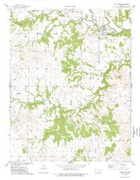
1975 Map of Fall River
USGS Topo · Published 1978About this map
Fall River sits at the northern edge of this Kansas landscape, positioned where the St Louis - San Francisco railroad tracks cross the water. The survey reveals a rural territory defined by the winding paths of Salt Creek, Indian Creek, and Mid Painterhood Cr. The terrain is marked by small settlements and family landmarks such as the Fleming area, which includes the Fleming Cem and nearby Mount Zion Ch.
Find a feature on this map
23 named features on this map. Tap any name to fly to it.
Don’t see what you’re looking for? This feature index may not catch every label — zoom into the map to look around manually.
Map Details
Editions of this 1975 Fall River Map
This is the sole edition of this map. No revisions or reprints were ever made.
Other maps of this area

1885 · Eureka
USGS Topo · 1:125,000

1885 · Sedan
USGS Topo · 1:125,000

1886 · Fredonia
USGS Topo · 1:125,000

1886 · Independence
USGS Topo · 1:125,000

1888 · Eureka
USGS Topo · 1:125,000

1889 · Sedan
USGS Topo · 1:125,000

1894 · Fredonia
USGS Topo · 1:125,000

1894 · Independence
USGS Topo · 1:125,000
1894 · Eureka
USGS Topo · 1:125,000

1905 · Independence
USGS Topo · 1:125,000