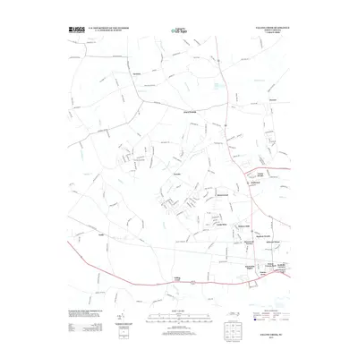
2013 Map of Falling Creek
USGS Topo · Published 2013About this map
Wheat Swamp and the meandering course of Falling Creek define the geography of this Lenoir County landscape during the early 21st century. The map depicts a transition from the agricultural heritage of Hardison Crossroads and Fields to the expanding residential outskirts of Kinston, evidenced by a dense network of suburban developments like Castle Oaks, Random Woods, and Kinstonian Heights. The area is characterized by a high degree of integration between older rural settlements like Institute and Dawson and modern infrastructure, including the C F Harvey Pkwy. Local history is preserved in named family landmarks such as Hugh E Hardy Rd and Harrison Phelps Rd. Small water bodies and tributaries like Gum Swamp Creek, Jumping Run, and Pulley Pond segment the terrain, while the eastern edge shows the structured growth around Mount Vernon Park and Rochelle Corners.
Find a feature on this map
162 named features on this map. Tap any name to fly to it.
Don’t see what you’re looking for? This feature index may not catch every label — zoom into the map to look around manually.
Map Details
Editions of this 2013 Falling Creek Map
This is the sole edition of this map. No revisions or reprints were ever made.
Other maps of this area

1914 · Kinston
USGS Topo · 1:48,000

1916 · Kinston
USGS Topo · 1:62,500

1953 · Rocky Mount
USGS Topo · 1:250,000

1954 · Rocky Mount
USGS Topo · 1:250,000

1957 · Goldsboro
USGS Topo · 1:62,500

1957 · Seven Springs
USGS Topo · 1:62,500

1958 · Deep Run
USGS Topo · 1:62,500

1980 · Seven Springs
USGS Topo · 1:24,000
1980 · Deep Run
USGS Topo · 1:24,000
1980 · Rivermont
USGS Topo · 1:24,000