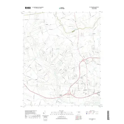
2019 Map of Falling Creek
USGS Topo · Published 2019About this map
Kinston sits at the southern edge of this landscape, where the Neuse River bends near the mouth of Falling Creek. The map documents a transition from the urban periphery to the agricultural reaches of the Greene and Lenoir county line. The terrain is defined by a dendritic network of low-lying wetlands and runs, including Jumping Run, White Marsh Run, and Wheat Swamp, which weave between family-named roads and scattered settlements. To the north and west, smaller communities such as Institute, Dawson, and Fields are connected by a web of rural routes like Haywood Hill Rd and Grays Mill Rd. Near the city, significant local landmarks are detailed, including Pinelawn Cem, Temple Israel Cem, and Westview Cem, providing a precise look at the memorial and geographic layout of the area as it stood in the late 2010s.
Find a feature on this map
122 named features on this map. Tap any name to fly to it.
Don’t see what you’re looking for? This feature index may not catch every label — zoom into the map to look around manually.
Map Details
Editions of this 2019 Falling Creek Map
This is the sole edition of this map. No revisions or reprints were ever made.
Other maps of this area

1914 · Kinston
USGS Topo · 1:48,000

1916 · Kinston
USGS Topo · 1:62,500

1953 · Rocky Mount
USGS Topo · 1:250,000

1954 · Rocky Mount
USGS Topo · 1:250,000

1957 · Goldsboro
USGS Topo · 1:62,500

1957 · Seven Springs
USGS Topo · 1:62,500

1958 · Deep Run
USGS Topo · 1:62,500

1980 · Seven Springs
USGS Topo · 1:24,000
1980 · Deep Run
USGS Topo · 1:24,000
1980 · Rivermont
USGS Topo · 1:24,000