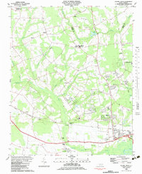
1983 Map of Falling Creek
USGS Topo · Published 1983About this map
The Atlantic and East Carolina railroad corridor forms the industrial and transport backbone of this Lenoir County landscape during the early 1980s. Connecting the settlements of Falling Creek Station and Falling Creek, the rail line is flanked by numerous family and community landmarks, including Temple Israel Cem, Pinelawn Cem, and the Kennedy Mem Home. The geography is defined by a dense network of watercourses, where Wheat Swamp and Gum Swamp meet White Marsh before draining toward the Neuse River at the southern edge of the sheet.
Find a feature on this map
49 named features on this map. Tap any name to fly to it.
Don’t see what you’re looking for? This feature index may not catch every label — zoom into the map to look around manually.
Map Details
Editions of this 1983 Falling Creek Map
This is the sole edition of this map. No revisions or reprints were ever made.
Other maps of this area

1914 · Kinston
USGS Topo · 1:48,000

1916 · Kinston
USGS Topo · 1:62,500

1953 · Rocky Mount
USGS Topo · 1:250,000

1954 · Rocky Mount
USGS Topo · 1:250,000

1957 · Goldsboro
USGS Topo · 1:62,500

1957 · Seven Springs
USGS Topo · 1:62,500

1958 · Deep Run
USGS Topo · 1:62,500

1980 · Seven Springs
USGS Topo · 1:24,000
1980 · Deep Run
USGS Topo · 1:24,000
1980 · Rivermont
USGS Topo · 1:24,000