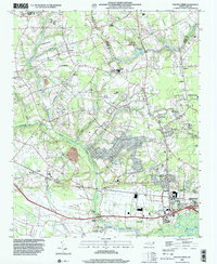
1998 Map of Falling Creek
USGS Topo · Published 2001About this map
Falling Creek and Moseley Creek define the low-lying hydrology of this coastal plain landscape as it appeared at the close of the twentieth century. The area is marked by a complex network of wetlands, including White Marsh Swamp and Wheat Swamp, which have historically shaped the settlement patterns of Lenoir Co and Greene Co. On the western edge of Kinston, the map reveals a transition from suburban development near the Neuse River to more dispersed rural communities such as Institute and Parrotts.
Find a feature on this map
44 named features on this map. Tap any name to fly to it.
Don’t see what you’re looking for? This feature index may not catch every label — zoom into the map to look around manually.
Map Details
Editions of this 1998 Falling Creek Map
This is the sole edition of this map. No revisions or reprints were ever made.
Other maps of this area

1914 · Kinston
USGS Topo · 1:48,000

1916 · Kinston
USGS Topo · 1:62,500

1953 · Rocky Mount
USGS Topo · 1:250,000

1954 · Rocky Mount
USGS Topo · 1:250,000

1957 · Goldsboro
USGS Topo · 1:62,500

1957 · Seven Springs
USGS Topo · 1:62,500

1958 · Deep Run
USGS Topo · 1:62,500

1980 · Seven Springs
USGS Topo · 1:24,000
1980 · Deep Run
USGS Topo · 1:24,000
1980 · Rivermont
USGS Topo · 1:24,000