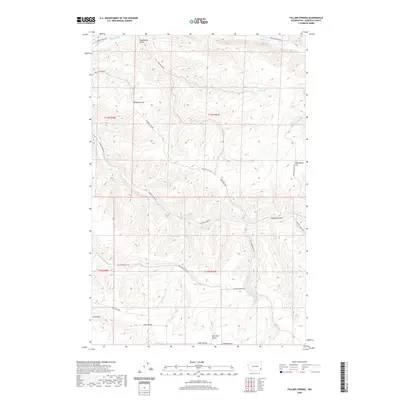
2020 Map of Falling Springs
USGS Topo · Published 2020About this map
Falling Springs and the surrounding high country of Garfield County define this landscape of deep drainages and prominent ridges. The area is characterized by a network of vital water sources including Seeley Spring, Wild Horse Spring, and Twin Springs, which likely served as crucial landmarks for early travelers and land managers in this part of Washington. A system of namesake roads and grades, such as Vannaton Grade and Kuhl Ridge Rd, traces the difficult topography, connecting the higher elevations of Kuhl Ridge to the complex canyon systems of Coyote Canyon and Breakdown Gulch. The prominence of Wild Horse Hill in the northeast suggests a history of local livestock or wildlife management. The drainage pattern, featuring Deadman Cr and Meadow Cr, illustrates how the terrain dictates the movement of both water and transportation through these remote reaches.
Find a feature on this map
29 named features on this map. Tap any name to fly to it.
Don’t see what you’re looking for? This feature index may not catch every label — zoom into the map to look around manually.
Map Details
Editions of this 2020 Falling Springs Map
This is the sole edition of this map. No revisions or reprints were ever made.
Other maps of this area

1937 · Pomeroy
USGS Topo · 1:96,000

1942 · Pomeroy
USGS Topo · 1:125,000

1950 · Penawawa
USGS Topo · 1:62,500

1950 · Hay
USGS Topo · 1:62,500

1952 · Hay
USGS Topo · 1:62,500

1955 · Pullman
USGS Topo · 1:250,000

1958 · Pullman
USGS Topo · 1:250,000
1967 · Pomeroy
USGS Topo · 1:24,000

1967 · Turner
USGS Topo · 1:24,000
1967 · Zumwalt
USGS Topo · 1:24,000