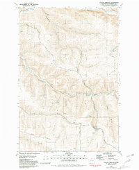
1981 Map of Falling Springs
USGS Topo · Published 1981About this map
Falling Springs and Twin Springs anchor this agricultural and drainage landscape in Garfield County during the early 1980s. The terrain is defined by a series of steep drainages, including Willow Gulch, Breakdown Gulch, and New York Gulch, which feed into larger watercourses like Deadman Creek and Meadow Creek. The distribution of scattered Storage Bins and several Gravel Pit sites reflects a rural economy centered on dryland farming and local material extraction.
Find a feature on this map
26 named features on this map. Tap any name to fly to it.
Don’t see what you’re looking for? This feature index may not catch every label — zoom into the map to look around manually.
Map Details
Editions of this 1981 Falling Springs Map
This is the sole edition of this map. No revisions or reprints were ever made.
Other maps of this area

1937 · Pomeroy
USGS Topo · 1:96,000

1942 · Pomeroy
USGS Topo · 1:125,000

1950 · Penawawa
USGS Topo · 1:62,500

1950 · Hay
USGS Topo · 1:62,500

1952 · Hay
USGS Topo · 1:62,500

1955 · Pullman
USGS Topo · 1:250,000

1958 · Pullman
USGS Topo · 1:250,000
1967 · Pomeroy
USGS Topo · 1:24,000

1967 · Turner
USGS Topo · 1:24,000
1967 · Zumwalt
USGS Topo · 1:24,000