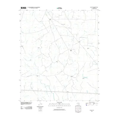
2010 Map of Fallon
USGS Topo · Published 2010About this map
Navasota River bottomlands define this portion of Limestone County, where a network of rural settlements and family landmarks anchor the landscape. Small hubs like Shiloh, Fallon, and Prairie Grove are connected by a dense grid of county roads, including Shiloh Rd and Prairie Grove Church Rd. For genealogists and local historians, the presence of Doyle Cemetery, Plummers Cemetery, and Bethel Cemetery provides specific points for ancestral research. The geography is characterized by numerous seasonal drainage paths such as Pin Oak Creek and Turkey Creek, which flow toward the river's main channel and its abandoned segments like Old Channel Navasota River. This drainage pattern influenced the placement of crossings such as the Long Bridge, which serves as a notable local landmark amidst the agricultural fields and scattered ponds like Moss Lake.
Find a feature on this map
61 named features on this map. Tap any name to fly to it.
Don’t see what you’re looking for? This feature index may not catch every label — zoom into the map to look around manually.
Map Details
Editions of this 2010 Fallon Map
This is the sole edition of this map. No revisions or reprints were ever made.
Other maps of this area

1920 · Mexia
USGS Topo · 1:62,500

1954 · Waco
USGS Topo · 1:250,000

1955 · Waco
USGS Topo · 1:250,000

1957 · Groesbeck
USGS Topo · 1:62,500

1960 · Groesbeck
USGS Topo · 1:24,000

1960 · Tehuacana
USGS Topo · 1:24,000

1963 · Teague North
USGS Topo · 1:24,000

1963 · Mexia
USGS Topo · 1:24,000

1966 · Thornton
USGS Topo · 1:24,000
1966 · Teague South
USGS Topo · 1:24,000