
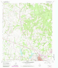
1963 Map of Teague North
USGS Topo · Published 1966About this map
The railroad junction at Teague anchors this Freestone County landscape, where the Chicago Rock Island and Pacific meets the Fort Worth and Denver line. This mid-century survey illustrates a community deeply connected by its schools and churches, featuring the Booker T Washington School and several rural congregations such as Wesley Ch and Union Prim Ch. To the north, the small settlements of Cotton Gin and Simsboro stand among a network of creeks, including Tehuacana Creek and Caney Creek. Local industry and infrastructure are evident in the scattered claypits and the Teague City Lake reservoir. The presence of both Gage Airfield and Gregory Field near the town center reflects the era's local aviation footprint, while family and community history is preserved at sites like Hopewell Cem and St Paul Ch.
Find a feature on this map
40 named features on this map. Tap any name to fly to it.
Don’t see what you’re looking for? This feature index may not catch every label — zoom into the map to look around manually.
Map Details
Editions of this 1963 Teague North Map
2 editions found
Other maps of this area

1919 · Fairfield
USGS Topo · 1:62,500

1920 · Mexia
USGS Topo · 1:62,500

1954 · Waco
USGS Topo · 1:250,000

1955 · Waco
USGS Topo · 1:250,000

1963 · Wortham
USGS Topo · 1:24,000

1963 · Kirvin
USGS Topo · 1:24,000
1963 · Stewards Mill
USGS Topo · 1:24,000

1963 · Mexia
USGS Topo · 1:24,000

1965 · Dew
USGS Topo · 1:24,000
1965 · Fairfield
USGS Topo · 1:24,000