
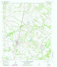
1963 Map of Wortham
USGS Topo · Published 1966About this map
Wortham serves as the central hub of this 1963 survey, where the Southern Pacific railroad cuts a straight line through the landscape, connecting the town with the smaller settlements of Currie to the north and Gude to the south. This era of Freestone County history is defined by the energy industry, evidenced by the extensive Wortham Oil Field, Currie Oil Field, and Tehuacana Oil Field which are marked by numerous oil wells and a complex network of pipelines crossing the terrain. Local institutions such as Wheeler High Sch and a Hospital anchor the town site, while rural life is marked by several burial grounds including Miller Cem, Red Cem, and Long Bottom Cem. The topography is shaped by the winding paths of Tehuacana Creek and Cedar Creek, providing a detailed look at the rural Texas countryside during the mid-1960s.
Find a feature on this map
38 named features on this map. Tap any name to fly to it.
Don’t see what you’re looking for? This feature index may not catch every label — zoom into the map to look around manually.
Map Details
Editions of this 1963 Wortham Map
2 editions found
Other maps of this area

1920 · Mexia
USGS Topo · 1:62,500

1954 · Waco
USGS Topo · 1:250,000

1955 · Waco
USGS Topo · 1:250,000

1957 · Groesbeck
USGS Topo · 1:62,500

1960 · Streetman
USGS Topo · 1:24,000

1960 · Tehuacana
USGS Topo · 1:24,000

1963 · Richland
USGS Topo · 1:24,000

1963 · Teague North
USGS Topo · 1:24,000

1963 · Kirvin
USGS Topo · 1:24,000

1963 · Mexia
USGS Topo · 1:24,000