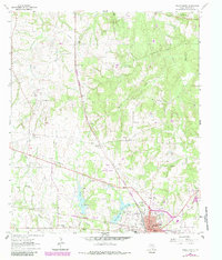
1963 Map of Teague North
USGS Topo · Published 1983About this map
The northern reaches of Teague and the surrounding Freestone County landscape are defined by a mix of agricultural history and industrial infrastructure as they appeared in the early 1960s, with later updates through 1982. The Burlington Northern railroad serves as a central spine for the region, passing through the heart of town and near the Teague Municipal Airport. Water management is prominent in the southern portion of the map, where Teague City Lake sits alongside the Upper Club Lake and Lower Club Lake reservoirs. These water bodies, situated near the Furney-Richardson Sch, suggest a landscape shaped for both local utility and recreation.
Find a feature on this map
35 named features on this map. Tap any name to fly to it.
Don’t see what you’re looking for? This feature index may not catch every label — zoom into the map to look around manually.
Map Details
Editions of this 1963 Teague North Map
2 editions found
Other maps of this area

1919 · Fairfield
USGS Topo · 1:62,500

1920 · Mexia
USGS Topo · 1:62,500

1954 · Waco
USGS Topo · 1:250,000

1955 · Waco
USGS Topo · 1:250,000

1963 · Wortham
USGS Topo · 1:24,000

1963 · Teague North
USGS Topo · 1:24,000

1963 · Kirvin
USGS Topo · 1:24,000
1963 · Stewards Mill
USGS Topo · 1:24,000

1963 · Mexia
USGS Topo · 1:24,000

1965 · Dew
USGS Topo · 1:24,000