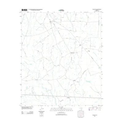
2013 Map of Fallon
USGS Topo · Published 2013About this map
The Navasota River and its intricate network of tributaries, including Pin Oak Cr and Plummers Cr, define this rural section of Limestone County. Small, dispersed settlements such as Shiloh, Fallon, and Prairie Grove are connected by a web of local routes like Ranch Road 1953 and FM-1245. For local historians, the map provides precise locations for Plummers Cem and Bethel Cem, while the Mitchell Energy site near Center points to the area's modern industrial footprint. The landscape's natural drainage patterns are clear as Turkey Cr and Middle Cr flow toward the river, which is crossed by the Long Bridge in the southwestern quadrant. This survey also records topographical landmarks like Morgan Hill, which rises above the surrounding ranch land and creek bottoms.
Find a feature on this map
71 named features on this map. Tap any name to fly to it.
Don’t see what you’re looking for? This feature index may not catch every label — zoom into the map to look around manually.
Map Details
Editions of this 2013 Fallon Map
This is the sole edition of this map. No revisions or reprints were ever made.
Other maps of this area

1920 · Mexia
USGS Topo · 1:62,500

1954 · Waco
USGS Topo · 1:250,000

1955 · Waco
USGS Topo · 1:250,000

1957 · Groesbeck
USGS Topo · 1:62,500

1960 · Groesbeck
USGS Topo · 1:24,000

1960 · Tehuacana
USGS Topo · 1:24,000

1963 · Teague North
USGS Topo · 1:24,000

1963 · Mexia
USGS Topo · 1:24,000

1966 · Thornton
USGS Topo · 1:24,000
1966 · Teague South
USGS Topo · 1:24,000