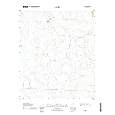
2019 Map of Fallon
USGS Topo · Published 2019About this map
The Navasota River and its intricate drainage network, including the Old Channel Navasota River, define this pocket of Central Texas. Small rural settlements like Fallon and Shiloh sit at the intersection of a dense grid of county roads, such as Co RD 436 and LCR 458, reflecting the area's agricultural foundations. The presence of Plummers Cem, Bethel Cem, and Doyle Cem offers critical waypoints for genealogists tracing family roots in this landscape of creek bottoms and low hills. From the prominent elevation of Morgan Hill down to the wetlands of Moss Lake and Duck Pond, the map reveals a terrain shaped by persistent watercourses like Pin Oak Cr and Plummers Cr. These features illustrate how the local geography influenced the placement of early crossings like Long Bridge, connecting remote farmsteads to the wider county.
Find a feature on this map
73 named features on this map. Tap any name to fly to it.
Don’t see what you’re looking for? This feature index may not catch every label — zoom into the map to look around manually.
Map Details
Editions of this 2019 Fallon Map
This is the sole edition of this map. No revisions or reprints were ever made.
Other maps of this area

1920 · Mexia
USGS Topo · 1:62,500

1954 · Waco
USGS Topo · 1:250,000

1955 · Waco
USGS Topo · 1:250,000

1957 · Groesbeck
USGS Topo · 1:62,500

1960 · Groesbeck
USGS Topo · 1:24,000

1960 · Tehuacana
USGS Topo · 1:24,000

1963 · Teague North
USGS Topo · 1:24,000

1963 · Mexia
USGS Topo · 1:24,000

1966 · Thornton
USGS Topo · 1:24,000
1966 · Teague South
USGS Topo · 1:24,000