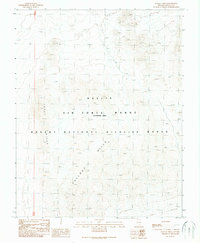
1989 Map of Fallout Hills
USGS Topo · Published 1989About this map
Nellis Air Force Range (Restricted Area) dominates this high-desert landscape in Lincoln County, Nevada, defined by its restricted status and physical isolation. The territory is characterized by a series of prominent geological formations including Chert Ridge and the namesake Fallout Hills, which rise above the desert floor. This 1989 provisional study was compiled from 1968 aerial photography, showing a terrain largely dedicated to military and conservation purposes. Overlapping with the military range is the Desert National Wildlife Range, illustrating the complex dual-use of this land for national security and environmental preservation. The lack of traditional civil settlements or roads highlights the strictly controlled nature of this corner of the Great Basin, where topographic contours and desert landforms remain the primary landmarks.
Find a feature on this map
5 named features on this map. Tap any name to fly to it.
Don’t see what you’re looking for? This feature index may not catch every label — zoom into the map to look around manually.
Map Details
Editions of this 1989 Fallout Hills Map
This is the sole edition of this map. No revisions or reprints were ever made.
Other maps of this area

1907 · Las Vegas
USGS Topo · 1:250,000

1908 · Las Vegas
USGS Topo · 1:250,000

1942 · Emigrant Valley
USGS Topo · 1:125,000

1942 · Indian Spring
USGS Topo · 1:125,000

1952 · Papoose Lake
USGS Topo · 1:62,500
1952 · Frenchman Lake
USGS Topo · 1:62,500

1954 · Caliente
USGS Topo · 1:250,000

1954 · Las Vegas
USGS Topo · 1:250,000

1957 · Las Vegas
USGS Topo · 1:250,000

1959 · Caliente
USGS Topo · 1:250,000