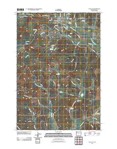
2011 Map of Falls City
USGS Topo · Published 2011About this map
Falls City serves as the primary hub in this corner of Polk County, where the Little Luckiamute River flows toward the larger valley. The map reveals a landscape defined by timber history and small-scale agriculture, evidenced by the network of mountain roads like Valsetz Rd and Bald Mountain Rd. Local history and genealogy are well-represented by several burial sites, including the Falls City Cemetery and the Falls City Odd Fellows Cemetery, as well as the Hubbard Cemetery to the southeast. To the south, the rural character of the McTimmonds Valley is highlighted by the Fir Grove School and several reservoirs such as Morgan Reservoir and Maddux Reservoir, which support the drainage basins of North Fork Pedee Creek and the Luckiamute River near the small settlement of Pedee.
Find a feature on this map
70 named features on this map. Tap any name to fly to it.
Don’t see what you’re looking for? This feature index may not catch every label — zoom into the map to look around manually.
Map Details
Editions of this 2011 Falls City Map
This is the sole edition of this map. No revisions or reprints were ever made.
Other maps of this area

1914 · Soap Creek
USGS Topo · 1:31,680

1921 · Corvallis
USGS Topo · 1:62,500

1922 · Airlie
USGS Topo · 1:31,680

1939 · Marys Peak
USGS Topo · 1:62,500

1942 · Marys Peak
USGS Topo · 1:62,500

1942 · Corvallis
USGS Topo · 1:62,500

1942 · Valsetz
USGS Topo · 1:62,500

1942 · Dallas
USGS Topo · 1:62,500

1953 · Salem
USGS Topo · 1:250,000

1954 · Salem
USGS Topo · 1:250,000