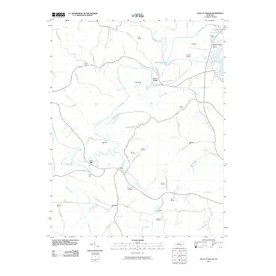
2010 Map of Falls of Rough
USGS Topo · Published 2010About this map
Falls of Rough serves as the focal point for this landscape, where the Rough River was managed for modern recreation and utility. The northeast corner is dominated by the Rough River Dam and the southern reaches of Rough River Lake, while the river continues its winding path southwest past Hites Falls and Alum Hill. This 2010 survey reflects a rural community defined by family legacies, evidenced by the numerous small burial grounds such as Walker Cemetery, Patterson Cemetery, and Porters Cemetery scattered along the ridge tops.
Find a feature on this map
73 named features on this map. Tap any name to fly to it.
Don’t see what you’re looking for? This feature index may not catch every label — zoom into the map to look around manually.
Map Details
Editions of this 2010 Falls of Rough Map
This is the sole edition of this map. No revisions or reprints were ever made.
Other maps of this area

1922 · Leitchfield
USGS Topo · 1:48,000

1925 · Spring Lick
USGS Topo · 1:62,500

1925 · Leitchfield
USGS Topo · 1:62,500

1932 · Fordsville
USGS Topo · 1:62,500

1953 · Mc Daniels
USGS Topo · 1:24,000

1953 · Kingswood
USGS Topo · 1:24,000

1953 · Falls Of Rough
USGS Topo · 1:24,000
1953 · Glen Dean
USGS Topo · 1:24,000
1953 · Fordsville
USGS Topo · 1:24,000

1954 · Evansville
USGS Topo · 1:250,000