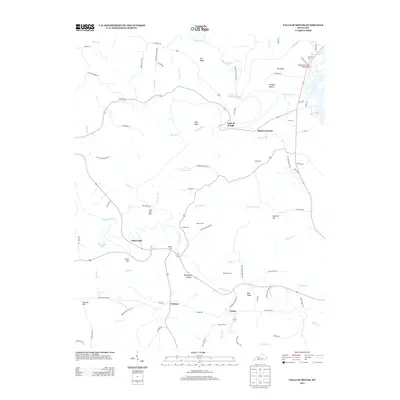
2013 Map of Falls of Rough
USGS Topo · Published 2013About this map
Falls of Rough and Hickory Corner anchor this early 21st-century landscape along the winding course of the Rough River. The area is characterized by a high density of small family cemeteries, such as Walker Cem, Smith Cem, and Patterson Cem, which serve as vital markers for genealogical research in this part of Grayson County. The topography is defined by distinctive landmarks like Iron Ore Hill and Ball Knob, while the northern reaches show the recreational impact of Rough River Lake and its associated facilities at the Rough River State Park Airport.
Find a feature on this map
93 named features on this map. Tap any name to fly to it.
Don’t see what you’re looking for? This feature index may not catch every label — zoom into the map to look around manually.
Map Details
Editions of this 2013 Falls of Rough Map
This is the sole edition of this map. No revisions or reprints were ever made.
Other maps of this area

1922 · Leitchfield
USGS Topo · 1:48,000

1925 · Spring Lick
USGS Topo · 1:62,500

1925 · Leitchfield
USGS Topo · 1:62,500

1932 · Fordsville
USGS Topo · 1:62,500

1953 · Mc Daniels
USGS Topo · 1:24,000

1953 · Kingswood
USGS Topo · 1:24,000

1953 · Falls Of Rough
USGS Topo · 1:24,000
1953 · Glen Dean
USGS Topo · 1:24,000
1953 · Fordsville
USGS Topo · 1:24,000

1954 · Evansville
USGS Topo · 1:250,000