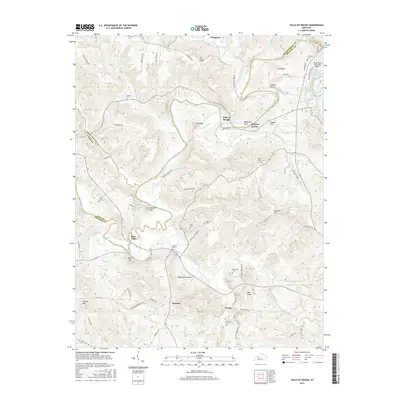
2016 Map of Falls of Rough
USGS Topo · Published 2016About this map
Rough River snakes through the borderlands of Breckinridge, Grayson, and Ohio Counties, anchoring a landscape defined by its sharp bends and narrow hollows. At the community of Falls of Rough, the river’s historical importance is evident, surrounded by significant terrain features like Hog Knob and Bugger Hill. The settlement pattern is dispersed, with small centers such as Yeaman, Tousey, and Hickory Corner connected by a network of rural roads, including the descriptive Old Railroad Bed Rd.
Find a feature on this map
92 named features on this map. Tap any name to fly to it.
Don’t see what you’re looking for? This feature index may not catch every label — zoom into the map to look around manually.
Map Details
Editions of this 2016 Falls of Rough Map
This is the sole edition of this map. No revisions or reprints were ever made.
Other maps of this area

1922 · Leitchfield
USGS Topo · 1:48,000

1925 · Spring Lick
USGS Topo · 1:62,500

1925 · Leitchfield
USGS Topo · 1:62,500

1932 · Fordsville
USGS Topo · 1:62,500

1953 · Mc Daniels
USGS Topo · 1:24,000

1953 · Kingswood
USGS Topo · 1:24,000

1953 · Falls Of Rough
USGS Topo · 1:24,000
1953 · Glen Dean
USGS Topo · 1:24,000
1953 · Fordsville
USGS Topo · 1:24,000

1954 · Evansville
USGS Topo · 1:250,000