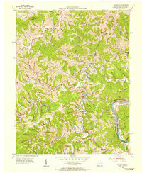
1953 Map of Fallsburg
USGS Topo · Published 1955About this map
Blaine Creek snakes through the heart of this Appalachian landscape, defining the character of eastern Kentucky just after the mid-century. The settlement of Fallsburg sits at a critical bend in the creek, surrounded by a network of rural schools and family chapels like Bradley Gap Ch and Newcomb Chapel. This era reveals a region heavily shaped by its geography and industrial infrastructure, with pipe lines cutting across the ridges and an extensive Oil Field stretching through the southern hills.
Find a feature on this map
48 named features on this map. Tap any name to fly to it.
Don’t see what you’re looking for? This feature index may not catch every label — zoom into the map to look around manually.
Map Details
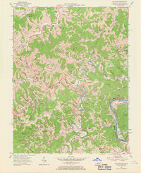
Editions of this 1953 Fallsburg Map
2 editions found
Other maps of this area

1901 · Ceredo
USGS Topo · 1:62,500

1903 · Kenova
USGS Topo · 1:125,000

1904 · Kenova
USGS Topo · 1:125,000

1911 · Louisa
USGS Topo · 1:48,000

1913 · Ceredo
USGS Topo · 1:62,500

1913 · Louisa
USGS Topo · 1:62,500

1939 · Louisa
USGS Topo · 1:62,500
1953 · Prichard
USGS Topo · 1:24,000

1953 · Rush
USGS Topo · 1:24,000

1953 · Boltsfork
USGS Topo · 1:24,000