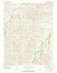
1955 Map of Falun
USGS Topo · Published 1973About this map
Falun stands as the central hub of this mid-century Kansas landscape, situated where the Missouri Pacific railroad cuts through the southeastern corner of the quadrangle. The map captures a distinct era of military land use, with the northern and central portions dominated by the Smoky Hill Air Force Base Bombing Range. This sprawling facility is defined by its topographic prominence and varied terrain, including features like Soldier Cap Mound and Potato Hill.
Find a feature on this map
17 named features on this map. Tap any name to fly to it.
Don’t see what you’re looking for? This feature index may not catch every label — zoom into the map to look around manually.
Map Details
Editions of this 1955 Falun Map
3 editions found
Other maps of this area

1892 · Salina
USGS Topo · 1:125,000

1942 · Salina
USGS Topo · 1:125,000

1955 · Salina SW
USGS Topo · 1:24,000

1955 · Smolan
USGS Topo · 1:24,000

1955 · Brookville
USGS Topo · 1:24,000

1955 · Falun
USGS Topo · 1:24,000

1955 · Hutchinson
USGS Topo · 1:250,000

1957 · Brookville SW
USGS Topo · 1:24,000
1957 · Venango
USGS Topo · 1:24,000

1959 · Hutchinson
USGS Topo · 1:250,000