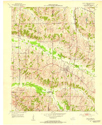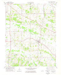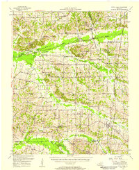
1952 Map of Fancy Farm
USGS Topo · Published 1958About this map
Fancy Farm and the surrounding agricultural uplands of western Kentucky are captured here in the early 1950s, a landscape defined by the winding drainages of Mayfield Creek and Obion Creek. The settlement pattern is anchored by small crossroads and parish centers such as Milburn, Lowes, and Lovelaceville. Genealogists will find a high density of rural landmarks, including the Mayfield Creek Ch & Cem and the St Charles Sch, which served as the social fabric for these farming communities. The Illinois Central railroad cuts through the northeastern corner, linking the region's produce to larger markets. From the wetlands of St Arbor Slough to the many family-named cemeteries like Martin Cem and Elsey Cem, the map illustrates a transition between the bottomlands and the rolling hills of the Jackson Purchase.
Find a feature on this map
64 named features on this map. Tap any name to fly to it.
Don’t see what you’re looking for? This feature index may not catch every label — zoom into the map to look around manually.
Map Details
Editions of this 1952 Fancy Farm Map
This is the sole edition of this map. No revisions or reprints were ever made.
Historical Maps of Bardwell Through Time
8 maps found