2022 Map of Fancy Gap
USGS Topo · Published 2022About this map
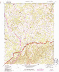
Carroll County's Blue Ridge landscape is heavily marked by familial legacy in this 2022 survey, as evidenced by an exceptional density of family cemeteries scattered across the high ridges. Named burial grounds like the Charles Harrison Webb Cem, Fielden A Worrell Cem, and Doctor Jesse Dickens Cem suggest generations of kinship and localized settlement patterns that defined this part of Virginia. The area's complex drainage system is clearly articulated, with the E Fork Little Reed Island Cr and W Fork Little Reed Island Cr converging in the western half, while Snake Creek carves through the eastern terrain. Along the higher elevations, prominent landmarks such as Wispering Ridge and Snow Mountain Ln dominate the geography. Significant spiritual centers like the Pleasant Grove Baptist Church Cem and Crooked Oak Moravian Church Cem serve as focal points for the rural community, connected by a network of winding mountain roads including Loggy Ridge Rd and Winding Ridge Rd.
Find a feature on this map
186 named features on this map. Tap any name to fly to it.
Don’t see what you’re looking for? This feature index may not catch every label — zoom into the map to look around manually.
Map Details
Editions of this 2022 Fancy Gap Map
This is the sole edition of this map. No revisions or reprints were ever made.