
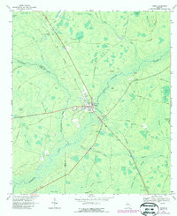
1967 Map of Fargo
USGS Topo · Published 1969About this map
Suwannee River flows through the heart of this South Georgia landscape, where the town of Fargo serves as a central hub for transportation and river monitoring. In the late 1960s, the area's infrastructure was defined by the intersection of the Southern Railway and local thoroughfares like the Woodpecker Route and Old Highway 94. The map reveals a specialized local economy, evidenced by the Golf Course, Landing Strip, and Lookout Tower situated near the town center.
Find a feature on this map
50 named features on this map. Tap any name to fly to it.
Don’t see what you’re looking for? This feature index may not catch every label — zoom into the map to look around manually.
Map Details
Editions of this 1967 Fargo Map
2 editions found
Other maps of this area

1954 · Valdosta
USGS Topo · 1:250,000

1955 · Council
USGS Topo · 1:24,000

1955 · Fargo SW
USGS Topo · 1:24,000

1956 · Sargent
USGS Topo · 1:24,000

1958 · Valdosta
USGS Topo · 1:250,000

1959 · Valdosta
USGS Topo · 1:250,000

1966 · The Pocket
USGS Topo · 1:24,000

1967 · Strange Island
USGS Topo · 1:24,000

1967 · Colon
USGS Topo · 1:24,000

1967 · Sargent
USGS Topo · 1:24,000