1969 Map of Farisita
USGS Topo · Published 1972About this map
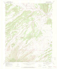
Farisita and Badito anchor this landscape along the Huerfano River, where the valley's water management is evidenced by the Garcia Ditch and Martin Ditch. The terrain is deeply grooved by a network of drainages including Oak Creek, Yellowstone Creek, and Turkey Creek, which carve through the high ground. For local historians and genealogists, the map reveals the locations of the Sanches Cem and an additional Cem near the river valley. The presence of numerous named springs such as Horse Spring, Willow Spring, and Dog Springs highlights the critical importance of reliable water sources in this arid Huerfano County environment during the late 1960s.
Find a feature on this map
19 named features on this map. Tap any name to fly to it.
Don’t see what you’re looking for? This feature index may not catch every label — zoom into the map to look around manually.
Map Details
Editions of this 1969 Farisita Map
3 editions found

Other maps of this area

1889 · Huerfano Park
USGS Topo · 1:125,000

1891 · Walsenburg
USGS Topo · 1:125,000

1892 · Huerfano Park
USGS Topo · 1:125,000

1894 · Walsenburg
USGS Topo · 1:125,000

1897 · Walsenburg
USGS Topo · 1:125,000

1900 · Walsenburg
USGS Topo · 1:125,000

1954 · Trinidad
USGS Topo · 1:250,000

1955 · Trinidad
USGS Topo · 1:250,000

1958 · Trinidad
USGS Topo · 1:250,000

1959 · Trinidad
USGS Topo · 1:250,000