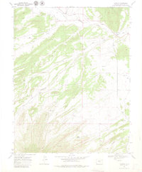
1969 Map of Farisita
USGS Topo · Published 1980About this map
Farisita and Badito sit at the confluence of arid plains and foothill drainages in Huerfano County, captured here as they appeared in the late 1960s. The settlement pattern is defined by the Huerfano River and its essential irrigation network, including the Garcia Ditch and Martin Ditch No 2. These waterworks highlight the vital link between the river and local agriculture in a landscape otherwise marked by seasonal draws like Yellowstone Creek and Oak Creek.
Find a feature on this map
27 named features on this map. Tap any name to fly to it.
Don’t see what you’re looking for? This feature index may not catch every label — zoom into the map to look around manually.
Map Details
Editions of this 1969 Farisita Map
3 editions found
Other maps of this area

1889 · Huerfano Park
USGS Topo · 1:125,000

1891 · Walsenburg
USGS Topo · 1:125,000

1892 · Huerfano Park
USGS Topo · 1:125,000

1894 · Walsenburg
USGS Topo · 1:125,000

1897 · Walsenburg
USGS Topo · 1:125,000

1900 · Walsenburg
USGS Topo · 1:125,000

1954 · Trinidad
USGS Topo · 1:250,000

1955 · Trinidad
USGS Topo · 1:250,000

1958 · Trinidad
USGS Topo · 1:250,000

1959 · Trinidad
USGS Topo · 1:250,000