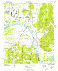
1947 Map of Farley
USGS Topo · Published 1956About this map
Laceys Spring and Farley anchor this mid-century portrait of the Tennessee River valley, where the water's path separates the lowlands from the rising topography of Wallace Mountain and Green Mountain. The Tennessee River, widened into Wheeler Lake, serves as the defining boundary between Madison, Morgan, and Marshall counties. This era reveals a landscape in transition as the Redstone Arsenal and Huntsville Arsenal reservations occupy the northwestern reaches, contrasting with the rural character of the southern hills.
Find a feature on this map
83 named features on this map. Tap any name to fly to it.
Don’t see what you’re looking for? This feature index may not catch every label — zoom into the map to look around manually.
Map Details
Editions of this 1947 Farley Map
This is the sole edition of this map. No revisions or reprints were ever made.
Other maps of this area

1885 · Gadsden
USGS Topo · 1:125,000

1888 · Cullman
USGS Topo · 1:125,000

1888 · Gadsden
USGS Topo · 1:125,000

1888 · Scottsboro
USGS Topo · 1:125,000

1888 · Huntsville
USGS Topo · 1:125,000

1892 · Cullman
USGS Topo · 1:125,000

1892 · Huntsville
USGS Topo · 1:125,000

1892 · Scottsboro
USGS Topo · 1:125,000

1892 · Gadsden
USGS Topo · 1:125,000

1895 · Gadsden
USGS Topo · 1:125,000