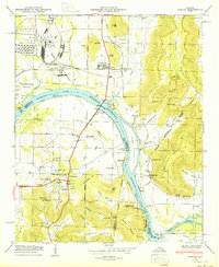
1950 Map of Farley
USGS Topo · Published 1950About this map
Redstone Arsenal and the Huntsville Arsenal dominate the western landscape of this mid-century survey, illustrating the rapid military industrialization of Northern Alabama. The Tennessee River Wheeler Reservoir carves through the center of the sheet, where the Nashville Chattanooga and St Louis Railway crosses the water near Hobbs Island. This infrastructure meets a deeply rooted rural geography defined by family-named landmarks and upland coves.
Find a feature on this map
85 named features on this map. Tap any name to fly to it.
Don’t see what you’re looking for? This feature index may not catch every label — zoom into the map to look around manually.
Map Details
Editions of this 1950 Farley Map
This is the sole edition of this map. No revisions or reprints were ever made.
Other maps of this area

1885 · Gadsden
USGS Topo · 1:125,000

1888 · Cullman
USGS Topo · 1:125,000

1888 · Gadsden
USGS Topo · 1:125,000

1888 · Scottsboro
USGS Topo · 1:125,000

1888 · Huntsville
USGS Topo · 1:125,000

1892 · Cullman
USGS Topo · 1:125,000

1892 · Huntsville
USGS Topo · 1:125,000

1892 · Scottsboro
USGS Topo · 1:125,000

1892 · Gadsden
USGS Topo · 1:125,000

1895 · Gadsden
USGS Topo · 1:125,000