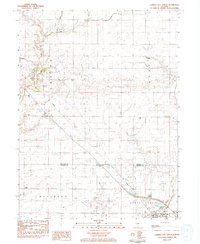
1983 Map of Farmer City North
USGS Topo · Published 1983About this map
Salt Creek and its North Fork dominate the northern landscape of this McLean and DeWitt County border region in the early 1980s. The geography transitions from the riparian corridors near LeRoy to the organized agricultural townships of Empire, West, and Rutledge. Local heritage is anchored by sites like Oak Grove Cem and Howard Cem, while the Townhall at Sabina marks a quiet center for the rural community. The map illustrates a period of established infrastructure, where the Conrail and Gulf Central Illinois rail lines cut through the plains, connecting small stations such as Watkins and Empire. Unique preserves like the Howard Virgin Timber Park stand out against the surrounding farmland, alongside leisure developments like the LeRoy Golf Course and Woodland Golf Course near Farmer City.
Find a feature on this map
23 named features on this map. Tap any name to fly to it.
Don’t see what you’re looking for? This feature index may not catch every label — zoom into the map to look around manually.
Map Details
Editions of this 1983 Farmer City North Map
This is the sole edition of this map. No revisions or reprints were ever made.
Other maps of this area

1937 · Monticello
USGS Topo · 1:48,000

1943 · Monticello
USGS Topo · 1:62,500

1951 · Le Roy
USGS Topo · 1:62,500

1952 · Arrowsmith
USGS Topo · 1:62,500

1957 · Maroa
USGS Topo · 1:62,500

1958 · Peoria
USGS Topo · 1:250,000

1961 · Peoria
USGS Topo · 1:250,000

1963 · Peoria
USGS Topo · 1:250,000

1979 · De Witt
USGS Topo · 1:24,000
1979 · Farmer City South
USGS Topo · 1:24,000