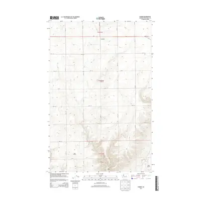
2014 Map of Farmer
USGS Topo · Published 2014About this map
The small settlement of Farmer serves as the focal point of this Douglas County upland, where the grid of the Public Land Survey System defines the agricultural landscape of Washington’s interior. Located along Us-2 and Baseline Rd E, the community is historically anchored by the Evangelical Emanuel Cem, reflecting the early 20th-century spiritual and social foundations of the local farming population. The terrain breaks sharply to the south into the dramatic geological depressions of Moses Coulee and Pine Canyon. These basalt-rimmed features, along with Peggy Canyon, disrupt the steady pattern of township roads like Road B SW and Road C NW, illustrating how the massive glacial-outburst floods of the prehistoric era continue to dictate the placement of transportation and homesteads across this high plateau.
Find a feature on this map
27 named features on this map. Tap any name to fly to it.
Don’t see what you’re looking for? This feature index may not catch every label — zoom into the map to look around manually.
Map Details
Editions of this 2014 Farmer Map
This is the sole edition of this map. No revisions or reprints were ever made.
Other maps of this area

1953 · Ritzville
USGS Topo · 1:250,000

1956 · Ephrata
USGS Topo · 1:62,500

1959 · Ritzville
USGS Topo · 1:250,000

1965 · Ritzville
USGS Topo · 1:250,000

1965 · Jameson Lake SW
USGS Topo · 1:24,000

1965 · Jameson Lake West
USGS Topo · 1:24,000
1966 · Palisades
USGS Topo · 1:24,000
1966 · Rattlesnake Springs
USGS Topo · 1:24,000

1968 · Withrow
USGS Topo · 1:24,000

1968 · Lamoine
USGS Topo · 1:24,000